Rondônia
The state of Rondônia in western Brazil — once home to 208,000 square kilometers of forest (about 51.4 million acres), an area slightly smaller than the state of Kansas — has become one of the most deforested parts of the Amazon. In the past three decades, clearing and degradation of the state’s forests have been rapid: 4,200 square kilometers cleared by 1978; 30,000 by 1988; and 53,300 by 1998. By 2003, an estimated 67,764 square kilometers of rainforest—an area larger than the state of West Virginia—had been cleared.
A chronological documentary of 60 moments on Loreline.
last updated 2026-07-21
Eras
- The Railway Era — Rondônia — The Railway Era.
- The Fishbone Roads — Rondônia — The Fishbone Roads.
- Satellite footage
- On the Ground — Rondônia — On the Ground.
- The Human Cost — Rondônia — The Human Cost.
- Wildlife Lost — Rondônia — Wildlife Lost.
- — Clearing for the Madeira-Mamoré Railway. c.1910. Forest felled to open the route for the Madeira-Mamoré railway — the first great clearing of Rondônia, decades before the highways.
- — Camp in Opened Forest. A railway-era camp inside a freshly opened stretch of Amazon forest — the leading edge of settlement at the turn of the century.
- — Village Along the Railway Line. A settlement and its cleared land beside the Madeira-Mamoré line — the pattern of road-then-clearing that would define Rondônia.
- — The Devil's Railway. The Madeira-Mamoré railway, built through the jungle at the cost of thousands of lives, first opened this corner of the Amazon.
- — Paving BR-364. The World-Bank-funded paving of the BR-364 highway in the 1980s triggered a wave of settlement and clearing.
- — The colonization program. Government schemes settled hundreds of thousands of migrants along the new roads, each clearing their plot from the forest.
- — Chico Mendes, 1988. Chico Mendes the year of his death. His killing made the human cost of Amazon deforestation an international cause.
- — Chico Mendes at the Rubber Tree. Rubber-tapper and union leader Chico Mendes, 1988. He organized Amazon forest peoples against clearing and was murdered that December.
- — The murder of Chico Mendes. Rubber-tapper and union leader Chico Mendes, who fought to save the forest, was murdered by ranchers in December 1988.
- — Rondônia from Orbit — 2000. NASA satellite view of Rondônia in 2000, part of the Earth Observatory time series tracking the advance of clearing across the state.
- — Rondônia from Orbit — 2001. NASA satellite view of Rondônia in 2001, part of the Earth Observatory time series tracking the advance of clearing across the state.
- — Smoke and Fires — MODIS, 2002. NASA Terra/MODIS view of Rondônia, 2002 — smoke from hundreds of clearing fires drifts over the fishbone of cleared land.
- — Rondônia from Orbit — 2002. NASA satellite view of Rondônia in 2002, part of the Earth Observatory time series tracking the advance of clearing across the state.
- — Rondônia from Orbit — 2003. NASA satellite view of Rondônia in 2003, part of the Earth Observatory time series tracking the advance of clearing across the state.
- — Rondônia from Orbit — 2004. NASA satellite view of Rondônia in 2004, part of the Earth Observatory time series tracking the advance of clearing across the state.
- — Rondônia from Orbit — 2005. NASA satellite view of Rondônia in 2005, part of the Earth Observatory time series tracking the advance of clearing across the state.
- — Rondônia from Orbit — 2006. NASA satellite view of Rondônia in 2006, part of the Earth Observatory time series tracking the advance of clearing across the state.
- — Rondônia from Orbit — 2007. NASA satellite view of Rondônia in 2007, part of the Earth Observatory time series tracking the advance of clearing across the state.
- — Fires on the Amazon Frontier, 2007. August 12, 2007. Red dots mark active fires along the frontier where forest is being converted to farmland in Rondônia.
- — Rondônia from Orbit — 2008. NASA satellite view of Rondônia in 2008, part of the Earth Observatory time series tracking the advance of clearing across the state.
- — Rondônia from Orbit — 2009. NASA satellite view of Rondônia in 2009, part of the Earth Observatory time series tracking the advance of clearing across the state.
- — Rondônia from Orbit — 2010. NASA satellite view of Rondônia in 2010, part of the Earth Observatory time series tracking the advance of clearing across the state.
- — Rondônia from Orbit — 2011. NASA satellite view of Rondônia in 2011, part of the Earth Observatory time series tracking the advance of clearing across the state.
- — Rondônia from Orbit — 2012. NASA satellite view of Rondônia in 2012, part of the Earth Observatory time series tracking the advance of clearing across the state.
- — Rondônia Deforestation — 18 June 2014. Landsat view, June 18 2014. Intact forest (dark green) is steadily replaced by the pale geometric grid of pasture and crops.
- — Rondônia Deforestation — 21 June 2015. Landsat view, June 21 2015 — a year on from the 2014 frame, the cleared corridors widening along the access roads.
- — Rondônia Deforestation — 25 July 2016. Landsat view, July 25 2016. By now the original solid forest survives mainly as islands inside a sea of cleared land.
- — The logging roads. Illegal logging roads push ever deeper, opening the forest to settlers and ranchers behind them.
- — Illegal logging. Loggers strip the most valuable hardwoods first, in operations that are largely illegal.
- — Land conflict and violence. The frontier is violent: land-grabbers, gunmen and the killing of activists and small farmers.
- — The jaguar's shrinking world. The jaguar, the Amazon's apex predator, loses habitat and prey as the forest is cleared and burned.
- — Cattle on the cleared land. Most cleared Amazon land becomes cattle pasture — Brazil's beef frontier drives the deforestation.
- — The fishbone from the air. Drone and aerial footage reveals the herringbone 'fishbone' pattern of roads eating into the forest.
- — The 2019 Amazon Fires. 2019’s fire season drew global attention as clearing fires across Rondônia and the wider Amazon sent smoke as far as São Paulo.
- — Cleared Land at Espigão do Oeste. Aerial view over Espigão do Oeste, 2019 — pasture and smallholdings carved out of what was continuous forest a generation earlier.
- — Cattle and the Clearing Front. Footage from the Rondônia clearing front — logging, burning and the cattle ranches that replace the forest.
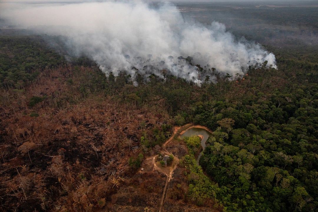
- — Burning Beside the Highway. A fire set to clear land along an Amazon highway, 2019 — the same slash-and-burn method that drove Rondônia’s clearing for decades.
- — The Bolsonaro years. Under President Bolsonaro (2019-2022), enforcement was gutted and deforestation surged to a 15-year high.
- — The clearing front. On the ground at the frontier: chainsaws, bulldozers and the burning of freshly-felled forest.
- — The 2019 fires. In August 2019 fires set to clear land raged across Rondônia and the Amazon, darkening the sky over São Paulo.
- — Animals in the fire. The 2019 fires killed and injured countless animals; rescuers pulled survivors from the ash.
- — The forest guardians. Indigenous 'forest guardians' risk their lives confronting illegal loggers — several have been killed.
- — The Uru-eu-wau-wau's fight. The Uru-eu-wau-wau people patrol their territory against invaders who burn and clear their forest.
- — Uprooted communities. Traditional rubber-tappers, riverine communities and Indigenous peoples are pushed off the land they depend on.
- — Forty years from orbit. Time-lapse satellite imagery shows Rondônia's forest dissolving into farmland over four decades.
- — The vanishing primates. Woolly monkeys, spider monkeys and titis lose the canopy they need to survive.
- — Soy and the frontier. Beyond the cattle, soybean plantations push the agricultural frontier deeper into the forest.
- — Wildcat gold mining. Illegal 'garimpo' gold mining poisons the rivers of the Amazon with mercury.
- — INPE and the deforestation alarm. Brazil's INPE space agency measures the forest loss that spiked to record highs around 2020-2021.
- — A world of species, lost. The Amazon holds a tenth of the world's known species — deforestation drives many toward extinction.
- — The scar seen from space. NASA and ESA satellites track the advancing deforestation front across the Brazilian Amazon.
- The Fishbone Pattern. The signature "fishbone": settlers clear narrow plots perpendicular to a central road, leaving a herringbone scar visible from orbit.
- Forest and Fields. Planet Labs high-resolution frame: the hard boundary between standing forest and the cleared fields that replace it.
- BR-364 — The Road In. The BR-364 highway. Paved through Rondônia in the 1980s, it opened the state to mass settlement — every fishbone branches off a road like this.
- BR-364 at Ji-Paraná. BR-364 running through Ji-Paraná, one of the boom towns that grew along the highway as colonists poured into Rondônia.
- What the Clearing Leaves. Degraded, fragmented forest — the thinned remnant left behind after selective logging and repeated burning.
- Uru-eu-wau-wau Territory. The Uru-eu-wau-wau Indigenous Land in Rondônia — protected forest that invaders repeatedly clear and burn, often violently.
- Chico Mendes Extractive Reserve. The extractive reserve named for Chico Mendes — a model of protected forest where traditional communities harvest without clearing.
- Jaguar. The jaguar (Panthera onca) — apex predator of the Amazon, its range fragmented and shrunk by every road and pasture cut into the forest.
- Brown Woolly Monkey. The brown woolly monkey, a canopy-dwelling Amazon primate that cannot survive where the forest is cleared.
Full text archive: /loreline-text/rondonia.md