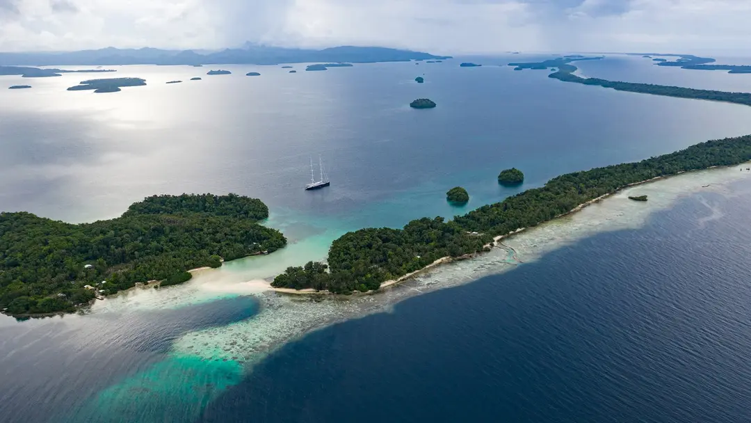
Solomon Islands
Nearly a thousand islands, about 700,000 people and somewhere north of seventy living languages, which makes this one of the most linguistically dense places on earth. People reached the main chain roughly 30,000 years ago, but the eastern islands waited for the Lapita voyagers around 1200 BC and the Polynesian outliers later still, so the country holds three settlement horizons about 28,000 years apart. Spanish ships arrived in 1568 and the name that stuck, attached later by other people, borrowed King Solomon and his mines to advertise a colony. Then labour ships, missions, a British protectorate, and in 1942 the largest war on earth landing on Guadalcanal, where islanders carried the wounded and scouted for the Allies and were mostly written out of the telling afterwards. Independence came in 1978, followed by the Tensions, an Australian-led intervention, riots that burned the same Honiara street twice under opposite foreign alignments, and a parliament that has changed prime ministers twice in 2026 alone. This archive is built mostly from what Solomon Islanders themselves put on the internet: string bands and panpipes, weddings and gardens and markets, Pijin lessons, reef and rain, and a war that is only one chapter of it.
A chronological documentary of 1,400 moments spanning 1625–2026 on Loreline.
Curated by Olivier · last updated 2026-09-20
Eras
- Sport, Futsal above all, where the Kurukuru have been Oceania champions and the national obsession is genuine; plus football, rugby, canoe racing, and the 2023 Pacific Games, which Honiara hosted and built for.
- - Battle of Munda (M. Merian). Battle of Munda (engraving by Matthäus Merian, cca 1625).
- - Nieuve Afteekening van Salomons eylanden of isles de Salomon. Sujet : Mendaña de Neyra, Alvaro (1541-1595) -- Voyages Salomon, Îles Ancien possesseur : Muller, Frederik (1817-1881). Ancien possesseur Couverture : Salomon Langue : néerlandais Éditeur : bij G.
- - Nouvel atlas de marine - Carte marine de la Nouvelle Zelande, des Isles Salomon et de plusieurs autres Isles meridionales - par Isaac Brouckner. Sujet : Monde -- Côtes Appartient à l’ensemble documentaire : AnvilFr Appartient à l’ensemble documentaire : MAEDI008 Appartient à l’ensemble documentaire : MAEDIGen0 Couverture : Monde (parties) Langue : français Éditeur : I. Brouckner (Berlin).
- - Plan of the Bay on the East side of the island Camorta - by James Rennell, 1762 ; publ. by A. Dalrymple. Sujet : Camorta, Île Trinkat, Île Appartient à l’ensemble documentaire : AnvilMF Couverture : Inde Langue : anglais Éditeur : A. Dalrymple.
- - Plan of Abai harbour on the NW coast of Borneo - by James Rennell, 1762 ; writing by T. Harmar. Sujet : Bornéo, Île de -- Nord-Ouest Appartient à l’ensemble documentaire : AnvilMF Couverture : Asie (parties) Langue : anglais Éditeur : A. Dalrymple.
- - Sambeelan islands in the strait of Malacca - by Mr. Rennell, 1763 ; publ. by A. Dalrymple ; engrav'd by Harmar. Sujet : Sambilan, Îles Appartient à l’ensemble documentaire : AnvilMF Couverture : Malaisie Langue : anglais Éditeur : A. Dalrymple.
- - Plan of port Praslin, discovered in the ship S. Jean-Baptiste commanded by Chevalier de Surville, 1769 - engrav'd by T. Harmar. Sujet : Nouvelle-Bretagne, Île de -- Côtes Port Praslin Appartient à l’ensemble documentaire : AnvilMF Couverture : Asie (parties) Papouasie-Nouvelle-Guinée Langue : anglais Éditeur : A. Dalrymple.
- - Historical Collection Dalrymple 1771 Ontong Java b30411543 0412. Ontong Java. Appeared thus when it bore S.
- - Les Îles Bourdé et du Salomon situées à l'O.S.O. du banc du Speaker. Sujet : Peros Banhos (atoll) Salomon, Îles Couverture : Territoire britannique de l'Océan Indien (Royaume-Uni) Langue : français.
- - Plan of the bay Choiseuil from Bougainvilles voyage ; Plan of Mackrel bay and water bay on the s. coast of New Guinea from Dampier ; Port Montague on New Britain from Dampier - W.H. (sculp.). Sujet : Dampierre (16..-17..? ; capitaine) -- Voyages -- Nouvelle-Guinée (île) Bougainville, Louis Antoine de (1729-1811) -- Voyages -- Nouvelle-Guinée (île) Nouvelle-Guinée (île) -- Côtes Nouvelle-Bretagne, Île de -- Côtes Louisiade, Archipel de la -- Côtes Appartient à l’ensemble documentaire : AnvilMF Couverture : Asie (parties) Papouasie-Nouvelle-Guinée Langue : anglais Éditeur : A.
- - Naufrage du navire l'Astrolabe en 1788. Naufrage de l’ Astrolabe en 1788 sur les récifs de l’île de Vanikoro lors d'une tempête. En arrière plan, la Boussole sur le point de s'échouer aussi.
- - Voyage de La Pérouse autour du monde (No. 44). Voyage de La Pérouse autour du monde /publié conformément au décret du 22 avril 1791, et rédigé par L.A. Milet-Mureau.
- - Sketch of the Duff group Islands 1797. Sketch of the Duff's Groupe, Discovered September 25, 1797 by Capt: James Wilson. Scale of two miles With views of the islands: Treasurers Island, Disappointment Island, Isle the Basse.
- - MemphisJamesRennell01. Map of Cairo and region in 1799 : Explaining the ( ancient siting ) position of Memphis and the changes in the course, islands, and ancient branches of the Nile. Created and published by James Rennell; September 2, 1799.
- - Canoe of the Arsacides. plate 44 from Voyage in Search of La Pérouse by Jacques Labillardière, 1800.
- - Grere'o shield, Solomon Islands. A basketry shield faced with parinarium-nut paste and inlaid with chambered-nautilus shell. Fewer than two dozen of these decorated Solomon Islands shields are known to survive.
- - Lettre de Jean-François Caplin au sujet de sa carte gravée des îles Vanikoro, Vaugirard, 15 septembre 1831 - (1 of 2). Sujet : Caplin, Jean-François (1779-1829?). Plan des Iles Vanikoro ou de La Pérouse, reconnues par le Capitaine de Frégate Dumont d'Urville Nouvelle-Zélande Société de géographie (France) Appartient à l’ensemble documentaire : MssSGE1 Archives Couverture : Nouvelle-Zélande Langue : français.
- - Durville-Vanikoro-Vanou. Village de Vanou à Vanikoro, 1833. Expédition de Jules Dumont d'Urville.
- - Durville-Vanikoro-Manevai-1. Approche du village de Manevai à Vanikoro, 1833. Expédition de Jules Dumont d'Urville.
- - Durville-Vanikoro-Nama. Village de Nama à Vanikoro en 1833, expédition de Jules Dumont d'Urville.
- - Vanikoro.- 1. Plan d'une grande pirogue du village de Manerai; 2. Elevation de cette pirogue (NYPL b13624459-1266934). Vanikoro.: 1. Plan d'une grande pirogue du village de Manerai; 2.
- - Vue du village de nama. (Vanikoro.) (NYPL b13624459-1266953). Vue du village de nama. (Vanikoro.).
- - Village de manévai. (Vanikoro.) (NYPL b13624459-1266952). Village de manévai. (Vanikoro.).
- - Village de vanou. (Vanikoro.) (NYPL b13624459-1266954). Photograph dated 1833. Part of the archive's coverage of the Australian brumby and the Kosciuszko cull.
- - Vanikoro.- 1. Ceinture; 2. 3. Ornamens d' oreilles; 4. 5. Ornamens de ne; 6. 7. Bracelets; 8. Plague de col; 9. Ornament du frent; 10. 11. Vase á raper le Tare; 13. Maniére de raper le Tare; (NYPL b13. Vanikoro.: 1. Ceinture; 2.
- - Durville-Vanikoro-Astrolabe. La corvette L'Astrolabe en vue de Vanikoro, 1833, expédition Dumont d'Urville.
- - Durville-Vanikoro-Platyrhynque. Platyrhynque de Vanikoro mâle, expédition Dumont d'Urville, 1833.
- - Durville-Vanikoro-coiffures. Coiffures des indigènes de Vanikoro, 1833, Expédition Dumont d'Urville.
- - Tikopia et Vanikoro.- Costume des habitans de Vanikoro; Cstumes des habitans de Tikopia (NYPL b13624459-1266955). Tikopia et Vanikoro.: Costume des habitans de Vanikoro; Cstumes des habitans de Tikopia.
- - Vanikoro.- 1. Plan et coupe d'un radeau; 3. 4. 5. Plan élévation et coupe d'une patite pirogue; 6. 7. Grande et petite pagaies (NYPL b13624459-1266933). Vanikoro.: 1. Plan et coupe d'un radeau; 3.
- - Vanikoro.- Coiffures des habitans des deux séxes (NYPL b13624459-1266905). Vanikoro.: Coiffures des habitans des deux séxes.
- - Plan des Îles Vanikoro ou de La Pélouse, reconnues par le capne de Frégate Dumont D'urville. Levé et drefsé par Mr. Cressien, Enseigne de vaifseau. expedition de la corvette de la corvette (NYPL b1362. Photograph dated 1833. Part of the archive's coverage of the law and the political fight over wild horses.
- - Inauguration du monument, elevé par l' Astrolabe à Lapérouse (i.e., La Pérouse) à Vanikoro (NYPL b13624459-1266957). Photograph dated 1833. Part of the archive's coverage of the law and the political fight over wild horses.
- - La corvette l'Astrolabe. envue de l'île Vanikoro (NYPL b13624459-1266946). Photograph dated 1833. Part of the archive's coverage of the law and the political fight over wild horses.
- - Les Chefs de Tikopia. recevant les officiers de l' Astrolabe (NYPL b13624459-1266945). Photograph dated 1833. Part of the archive's coverage of the law and the political fight over wild horses.
- - Vue du l'ile Manévai. (Vanikoro.) (NYPL b13624459-1266951). Vue du l'ile Manévai. (Vanikoro.).
- - Tikopia.- 1. 2. Naturels de Tikopia; 3. Tafoua chef de Tikopia; 4. Bréatafou, son fils; 5. Martin Buchert, matelot, né à Stettin en Prusse (NYPL b13624459-1266948). Tikopia.: 1. 2. Naturels de Tikopia; 3. Tafoua chef de Tikopia.; 4. Bréatafou, son fils; 5. Martin Buchert, matelot, né à Stettin en Prusse.
- - Vanikoro.- 1. Tangaroa de manévé; 2. Mériko chef à manévé; 3. Oumou chef à nama; 4. Maingho de Manévé; 5. Naturel de Manévé (NYPL b13624459-1266947). Vanikoro.: 1. Tangaroa de manévé; 2.
- - Vanikoro.- 1. Monbai; 2. Naturel de vanou; 3. Naturel de vanou; 4. Femme de Pako Chef de Manéva; 5. Valie chef de Vanou; 6. Chef de l' the vanikoro (NYPL b13624459-1266939). Vanikoro.: 1. Monbai; 2.
- - Oiseaux- 1. Tangara Grive. mâle. (Nouv.-Zelande.); 2. Merle de vanikoro, femelle. (Vanikoro.) (NYPL b13624459-1267043). Oiseaux: 1. Tangara Grive.
- - Poissons- 1. Girelle de vanikoro. (Vanikoro.); 2. Girelle trimaculée. (Vanikoro.); 3. Labre Large-raie. (Hâbre Dorey.); 4. Labre perditions. (Tongatabou.); 5. Girelle de l'Ascension. (NYPL b13624459-1. Poissons: 1. Girelle de vanikoro.
- - Tikopia.- 1. 2. 3. 4. Portraits d' habitans de Tikopia; 5. Tatouage de la poitune (NYPL b13624459-1266959). Photograph dated 1833. Part of the archive's coverage of the law and the political fight over wild horses.
- - Solomon Ceremonial Shield LACMA M.2008.66.14 (1 of 2). Solomon Islands, Santa Isabel Island, circa 1800 Sculpture Basketry, parinarium nut paste, shell inlay, and pigment 36 1/4 x 11 x 2 1/2 in. (92.08 x 27.94 x 6.35 cm) Purchased with funds provided by the Eli and Edythe Broad Foundation with additional funding by Jane and Terry Semel, the David Bohnett Foundation, Camilla Chandler Frost, Gayle and Edward P.
- - Solomon Ceremonial Shield LACMA M.2008.66.14 (2 of 2). Solomon Islands, Santa Isabel Island, circa 1800 Sculpture Basketry, parinarium nut paste, shell inlay, and pigment 36 1/4 x 11 x 2 1/2 in. (92.08 x 27.94 x 6.35 cm) Purchased with funds provided by the Eli and Edythe Broad Foundation with additional funding by Jane and Terry Semel, the David Bohnett Foundation, Camilla Chandler Frost, Gayle and Edward P.
- - The whale boat returning to the Wanderer in the hurricane off Guadalcanal. 1851. 1822-1886, artist Date : ca.
- - Wanderer's Bay, Guadalcanal. 1851. 1822-1886, artist Date : ca.
- - A dorsal image of Victoria's Birdwing Butterfly, Ornithoptera victoriae, Gray, 1856. Photograph dated 1856. Part of the archive's coverage of the free-roaming herds of the world.
- - A ventral image of Victoria's Birdwing Butterfly, Ornithoptera victoriae, Gray, 1856. Photograph dated 1856. Part of the archive's coverage of the free-roaming herds of the world.
- - Queen Victoria's birdwing butterfly, female, Guadalcanal. Solomon Islands bird, wildlife subject recorded on Wikimedia Commons.
- - Manevai Bay, in the Vanikoro Island, a coral island. Manevai Bay, in the Vanikoro Island (islands with corals).
…and 1,350 more moments.
Full text archive: /loreline-text/solomon-islands.md